Pinglu Canal Map: Location, Route and Lock Hubs
Where is the Pinglu Canal? Located in Guangxi, China, running 134.2 km from Hengzhou on the Xijiang to Qinzhou Port. Route overview, connections and the three lock hubs.
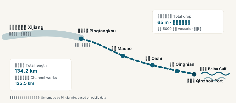
Tap a node on the map for details, or use the list below.
Map locations
- Pingtangkou (starting point)
Where the canal begins, linking the Xijiang waterway to the canal channel.
- Madao Hub
The controlling hub of the upstream Nanning section, first of the three cascading locks.
- Qishi Hub
The mid-route hub of the three cascading navigation hubs.
- Qingnian Hub
The downstream hub, closest to Qinzhou and the sea.
- Qinzhou Port / Beibu Gulf
Where the canal meets the sea, connecting to the Beibu Gulf port group and river-sea transport.
Related places
The Pinglu Canal is a river-to-sea canal in Guangxi Zhuang Autonomous Region, southern China, opened to navigation on September 16, 2026. This page explains where it is, what it connects, and how the route is laid out.
Where is the Pinglu Canal?
The canal lies in southern Guangxi, crossing two cities. Its northern starting point is Pingtangkou, on the Xijin reservoir near Hengzhou (a county-level city of Nanning), where the Xijiang trunk waterway meets the canal. From there the channel runs generally south along the Qinjiang river valley, passing Lingshan County in Qinzhou, and reaches the sea at Qinzhou Port on the Beibu Gulf (Gulf of Tonkin).
In plain terms: the canal is a waterway cutting south from the Xijiang river system straight to the coastline of southern China, facing Vietnam and the rest of ASEAN across the gulf.
What does it connect?
To the north, it joins the Xijiang waterway, Guangxi's main inland shipping artery with connections toward Yunnan, Guizhou and China's southwest. To the south, it opens into the Beibu Gulf at Qinzhou Port, one of the core ports of the Beibu Gulf port group. Before the canal, Guangxi's river cargo could only reach the sea eastward via Guangzhou; vessels can now sail south directly.
Route overview
- Total length about 134.2 km, of which the channel works span roughly 125.5 km
- Built to Class I inland waterway standards, navigable for 5,000-tonne vessels
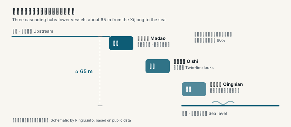
- Total water-level difference of about 65 metres from start to sea, handled by three cascading hubs
- Two waterway service areas (Xinfu and Qinzhou) provide supplies for vessels
The three lock hubs
From upstream to downstream, the canal steps down through three navigation hubs — Madao (the controlling hub in the Nanning section), Qishi (mid-route) and Qingnian (downstream, toward Qinzhou) — each with twin-line ship locks.
Where it meets the sea
The canal discharges into the Beibu Gulf near Qinzhou Port. Per the Ministry of Transport, China's first "equivalent Class-A navigation area" has been designated in the river-sea transition zone of Qinzhou Bay; inland vessels that meet the relevant conditions can sail via the canal into these waters and berth directly at Qinzhou's seaport terminals for cargo handling, without transshipment.
About this map
An interactive map is available for the main route and key locations — tap a hub along the channel for details. The underlying route graphic is a schematic, not an engineering or navigation chart.
- Start
- Pingtangkou, Hengzhou (Xijiang waterway)
- End
- Qinzhou Port (Beibu Gulf)
- Length
- ≈ 134.2 km
- Lock hubs
- Madao · Qishi · Qingnian
- Region
- Guangxi — Nanning / Qinzhou
- Status
- Opened to navigation on Sep 16, 2026
Sources (public reports, as of September 2026)
OfficialMinistry of Transport of China2026-09-08
The Pinglu Canal opens to navigation on September 16 — a century-old dream of river-to-sea access becomes realityView original ↗
MediaXinhua News Agency2026-09-17
Pinglu Canal opens a new chapter of openness to the sea (Xinhua Spotlight)View original ↗
OfficialPearl River Waterway Administration, MOT (citing Xinhua)2026-09-16
Pinglu Canal officially opens to navigationView original ↗
Compiled from public reports (as of September 2026); the schematic is not for engineering or navigation use.